“The majority of urban areas in most cities today are car-dependent,” writes urban planner Tristan Cleveland, “leaving little room for walkable growth unless cities can convert large areas of existing suburbs into pedestrian-oriented neighbourhoods.”
Yet the processes of change are even more difficult in suburbs than in urban cores:
“The barriers to walkable design are greatest in such suburban contexts, where the momentum for car-oriented design is most entrenched.”
Cleveland is an urban planning consultant who works with Happy Cities, a consultancy based in Halifax and Vancouver. His 2023 PhD thesis, Urban Intercurrence, is a thorough, enlightening, readable, jargon-lite study of how and why some suburban districts embark on the transition from car-dependent sprawl to walkable neighbourhoods. (A tip of the hat to Strong Towns, where I first learned of Tristan Cleveland’s work through this podcast interview.)
The work’s subtitle – “The Struggle To Build Walkable Downtowns In Car-Dependent Suburbia” – indicates an important limitation in scope. This is not a study of attempts to convert a car-dependent suburb as a whole, but more simply to develop a high-density, walkable district within a larger suburb. Even so, Cleveland demonstrates, the pitfalls are many and successes to date are partial at best.
Cleveland’s insights make for a good follow-up to recent posts here on car-dependent development. A first post, Recipes for Car-Dependency, looked at car-dependent development on a regional scale, in which a superfluity of highways and major arterial roads is matched with scarce, infrequent public transit. The second post, Building Car-Dependent Neighbourhoods, focused on car-dependent development at a neighbourhood scale.
But once car-dependent regions and neighbourhoods are established, is it possible to retrofit them, in whole or in part, to escape this car-dependency?
In my opinion it is not only possible, but is probably inevitable – though it may take a long time and it may involve difficult disruptions. Probably inevitable, because the suburban lifestyle is built on and presupposes cheap energy to power swarms of private cars which each carry one or two occupants many kilometers to work, school, and shopping on a daily basis. When this energy is no longer available and affordable to most residents, car-dependent lifestyles will change by necessity.
In the meantime, some residents and municipalities are already promoting car-lite or car-free lifestyles for other important reasons: to improve public health by simultaneously reducing air pollution and the diseases of sedentary lifestyles; to build social cohesion by encouraging more people to walk through their neighbourhoods to local shops; to cover rising infrastructure maintenance costs by achieving compact urban and suburban developments with a higher tax base; to make frequent and timely public transit possible in districts with sufficient population density.
As Cleveland notes, walkable neighbourhoods are in high demand but scarce supply, leading to sky-high rents and real estate prices in such districts. And since most North Americans now live in suburbs, providing the walkable neighbourhoods many people would prefer to live in will necessarily involve a significant degree of suburban retrofitting.
Urban Intercurrence provides detailed looks at four concerted attempts to build walkable downtown districts in suburbs. One is in a suburb of Vancouver, another in a suburb of Toronto, a third in a classic “edge city” in the orbit of Washington, DC, and one about ten miles from downtown Miami, Florida.
Before diving into the specifics of each project, Cleveland provides a valuable primer on a hundred years of car-prioritized developments. This history is essential to understanding why the retrofit examples have all had slow and limited success.
The history review and the examples are relevant and useful to transportation activists, environmental justice activists, municipal planners and officials.
Intercurrence and inverse feedback
For a PhD thesis Urban Intercurrence is remarkably light on specialist jargon, and Cleveland also defines clearly what he means by words or phrases that may be unfamiliar to a lay audience. Many of the issues he discusses will be familiar to any activist who has attended public meetings in favour of adding bike paths, reducing width of car lanes, or repurposing some of the vast area now devoted to car parking.
There is, to be sure, an out-of-the-ordinary word in the thesis title. Cleveland adopts the word “intercurrence” from political science, where it refers to “the ways in which multiple, contradictory paradigms of thought and practice can co-exist within institutions, and how their contradictions can shape policy.” (Pg 5. Unless noted otherwise, all quotes in this article are from Urban Intercurrence.)
The contradictory paradigms sometimes come from professionals who are educated with different orientations. In recent decades the urban planning profession has been strongly influenced by the movement to create safe, attractive, walkable districts, Cleveland says. Traffic engineering departments, on the other hand, tend to prioritize the swift and unimpeded movement of vehicles. Both groups are involved in suburban retrofits, and sometimes the result is a project that spends much public money to encourage walkability, and just as much or more money widening car lanes on more roadways, thereby discouraging walkability.
A paradigm like car-dependency tends to be self-reinforcing. If nearly all the residents in a district travel by car, then shopping centers have their doors opening to large parking areas, instead of opening directly to a sidewalk where the rare pedestrian might pass by. If each single-family home needs two or three parking spaces, then residents and their municipal councillors typically fear that even a mid-size apartment building will overwhelm the neighbourhood’s parking supply.
Nevertheless, car-dependency sometimes causes discontent with car-dependency. In many suburban areas today, roadways are so chronically congested that voters are ready to approve new public transit systems. At the same time, housing developers used to building low-density, car-dependent subdivisions may switch to advocating for high-density developments once they’ve used up most of the available land.
Cleveland writes,
“I refer to these contradictory feedback processes — which undermine car-dependence, reinforce walkability, or at least enable a shift towards walkability — as ‘inverse feedback.’” (pg 5)
He cites clear examples of competing paradigms and inverse feedback in each of the four suburban retrofit case studies. In each case, inverse feedback provides an opening for walkability advocates to initiate change. Importantly, however, when car-oriented interests offer support to walkability, that support is limited and insufficient to result in a walkable neighbourhood:
“To complete a shift to walkability, it is necessary, at some point, for walkability to begin to reinforce itself on its own terms, at the expense of car-dependence. That is to say: it is necessary for walkable interests to identify as such, to defend their needs, to establish separate standards, and to normalize those standards. It is also essential for walkable development to achieve a sufficient scale that it can begin to attract other, similar growth. Car-dependence may cause backlash that inspires change, but to complete change, it is essential for those who have a direct stake in walkability to complete the transformation.” (pg 6)
The timeline is long, very long
Two important facts jump out when reading the four case studies of retrofits. First, change in these instances is primarily a top-down process, promoted and initiated by local governments, major developers, or both. Second, the move to walkability has taken thirty or forty years, with action stalled for years in some cases, and while significant progress has been made, none of the four projects have yet fully realized their original goals.
In Surrey, BC, a suburb of Vancouver, formal planning for a walkable downtown district began in the 1980s. Zoning changes alone failed to convince developers to build high-density projects geared to walkability. The city finally took major steps in the 21st century, building a new city hall and public library complex in a prime location. Even then developers hesitated, so in 2007
“The city established the Surrey City Development Corporation (SCDC), an arms-length company for which the city remained the sole shareholder, but which could raise capital, build market-oriented development projects, and partner with other development firms to help to encourage them to invest.” (pg 134)
The new developments were located adjacent to a station of the SkyTrain, a commuter train that goes to downtown Vancouver. The existence of the SkyTrain helped convince many car-dependent residents to support a walkable, high-density Surrey City Centre. However, this expensive transit line made it difficult to get funding for other intra-suburb lines that might have been of even more benefit in freeing Surrey residents from car-dependency. As Cleveland explains:
“A SkyTrain can appeal to otherwise car-dependent voters because it can replace the one trip that is most difficult to make by car — commuting through traffic to work — and it can also help to alleviate rush-hour traffic by replacing some of those car trips. And it does not consume road space. However, a SkyTrain to downtown does not meet the needs of people who rely on transit for everyday trips, such as going to daycare, visiting friends, or buying groceries. … A high-speed connection to the downtown makes one kind of trip faster, but does little to enable a complete transit-oriented lifestyle throughout one’s community.” (pg 145-146)

SkyTrain route from Surrey City Centre to downtown Vancouver (image via Apple Maps)
The interplay between transport decisions made by different levels of government has been a complicating factor in all four of the the suburban retrofits Cleveland examines.
Spontaneous generation
As Brian Eno sang on Before and After Science,
“If you study the logistics
and heuristics of the mystics
you will find that their minds rarely move in a line.”1
This aphorism comes to mind when considering the massive roadways that snake through the should-be-walkable suburban retrofits. The plans of the traffic engineers follow a curious logic indeed.
In his book Paved Paradise, Henry Grabar highlighted an assumption deeply embedded in North American traffic engineering. He discusses the Parking Generation Manual published in 1985 by the Institute of Traffic Engineers. Underpinning the nearly infinite specifications for required parking, Grabar says,
“the premise is simple: every type of building creates car trips, and projects should be approved, streets designed, and parking constructed according to the science of trip generation.”2
The belief that a building itself somehow generates traffic, and a multi-unit building generates multi-traffic, guides not only parking requirements but also roadway planning. In this thinking, it is not a car-dependent lifestyle or urban layout that generates traffic, it is the mere existence of buildings where people live, work, or shop. As long as this thinking guides traffic engineers, urban planners’ hopes for dense, walkable districts get sidetracked.
In the Uptown Core project in Oakville, Ontario, Cleveland writes,
“Traffic studies … predicted the community would have high traffic demand, requiring wide roads throughout the community. Studies predicted high traffic, ironically, precisely because the community was dense: traffic models assume each unit produces a certain number of traffic trips, regardless of whether the community is designed to be walkable or not.” (pg 203)
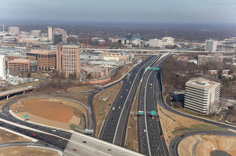
Tysons, Virginia is the largest and most famous suburban retrofit project in North America. As a classic “edge city,” Tysons in 1993 had few homes but a forest of high-rise office buildings where 70,000 people worked. The only way to get to these buildings was by car. Two examples of “inverse feedback” helped to prompt a retrofit: prime development land was getting scarce, and roads choked with traffic were undermining the original locational advantage for this mega office park.
Following a wave of investment in high-density housing, the population of Tysons rose to 29,000 by 2021, of which 10,000 lived in transit-oriented developments near the new Silver Line commuter rail service to Washington, DC.
But the planning for a walkable district had to contend with traffic engineers at the county and state level. They insisted that, ideals of walkability notwithstanding, Tysons would need to accommodate ever greater numbers of private vehicles. As a result, “Tysons’ smaller collectors and minor avenues are larger than the widest highways in many cities, at seven to ten lanes.” (pg 166)
Multi-lane highways even run directly past the commuter rail stations, making it unattractive or impossible to build new developments in close proximity to the stations. Ringed and bisected by high-speed, high-volume, high-pollution, very wide roads, Tysons can be summarized as “islands of walkability amidst rivers of car-dependence,” Cleveland writes. (pg 151)
Intercurrence in Tysons is reflected in government expenditures that work at cross-purposes:
“I am aware of few examples where government has spent so heavily to achieve a goal while spending so heavily to undermine it: billions of dollars on subways, sidewalks, and bike lanes, and nearly a billion dollars for widening roads and onramps, and billions more on widening its highways.” (pg 193)
Another lesson to be drawn is that “if it is difficult to shift one path-dependent institution, it is more difficult to shift two simultaneously, Cleveland writes.
“Multilevel governance can therefore create additional barriers to change, reducing the likelihood that all relevant institutions will shift to support walkability simultaneously.” (pg 180)
An all-or-nothing proposition?
Because the factors reinforcing suburban car-dependency are many and strong, and most suburban retrofits have had limited success to date, some urbanists have concluded that incremental approaches are doomed to failure.
Cleveland cites various authors who “argue it is better for a single developer to own enough land to build a full-scale walkable community at once, establishing a critical mass of dense housing, pedestrian-friendly streets, and high-quality public spaces, all within walking distance of local shops and services.” (pg 230)
But Cleveland concludes (correctly, I believe), that
“It is important for cities to learn how to implement incremental retrofits, because cities cannot achieve their most urgent goals by retrofitting those few exceptional sites where government owns a former airport, military base, or other large piece of land, and can redevelop it all at once.” (pg 230)
In a coming post we’ll look further at possibilities for incremental change toward walkable suburbs, including changes that are undertaken not by governments but directly by residents.
Notes
1 From the song “Backwater” on the album Before and After Science by Brian Eno, 1977.
2 Henry Grabar, Paved Paradise, Penguin Random House, 2023; pg 153.