The following post was co-authored by PPS’s Gary Toth and Kody Van Dyk, the Public Works Director for the town of Sandpoint, ID.

Photo: USA Today
PPS often says, ‘We have to stop building transportation through communities and instead build communities through transportation.’ Unfortunately, as logical as this may sound, Departments of Transportation and Public Works don’t often follow this path. Virtually every week, PPS learns of yet another project around the US where a community is facing significant impacts from a DOT project that will create a barrier to biking, walking and Placemaking in pursuit of automobile mobility. The culprits behind this thinking are policies present in virtually every DOT in the country, guiding them to design and build projects that can move vehicles freely through our communities during the one peak hour of each day, and to do so for volumes estimated to be present 20 to 25 years into the future.
The unanimous vote of the Idaho Transportation Board on June 19, 2013, to accept the recommendation of the Idaho Transportation Department (ITD) to defund a capacity increase project called “The Curve” demonstrates that this doesn’t have to be the case. ITD had the courage to take a second look at how it sought to address moving traffic through downtown Sandpoint, and to do so in a way that balanced the needs of the motoring public with the desires of Sandpoint to enhance walking and biking to, from, and within its downtown.
Sandpoint is an idyllic place in the Panhandle of Idaho. Don’t just take my word for it: USA Today voted it the 2012 Most Beautiful Small Town in America. Based on my three days there last month, you won’t get an argument from me. In addition to the beautiful lakes and views of mountains in each direction, Sandpoint is an early 20th century gridded community where virtually all of its approximately 7500 residents can walk to its downtown, lakefront, and parks. Like many small, medium, and large cities around the US, Sandpoint sits on several state highways that originally helped to bring prosperity to town. In fact, as US Highway 2 approaches downtown from the south, it splits into a northbound and southbound pair, with the northbound traffic actually circumnavigating downtown via three different streets first moving east on Pine Street, then north on First Avenue and then west on Cedar Street; southbound traffic splits at Cedar and passes along the edge of downtown via Fifth Avenue.

Northbound one way Route 2 in red / Southbound one way Route 2 in blue / Two way Route 2 in black
In addition to increased traffic including trucks, the overlaying of Route 2 on downtown streets presented another problem for Sandpoint. Idaho DOT had jurisdiction over these streets and this prevented Sandpoint from investing several million dollars they had raised to rightsize the streets by adding desired walking and biking infrastructure.
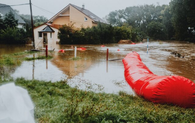
As Jane Jacobs once said: “The erosion of cities by automobiles proceeds as a kind of nibbling… A street is widened here, another is straightened there…cumulatively the effect is enormous.” Sandpoint did not escape this fate. The photo inset below shows the result of a major widening of US Route 2 that creates a barrier between the neighborhoods in Northwest Sandpoint and its downtown. Furthermore, Sandpoint was facing the specter of another regional road capacity project downtown, in the form of the long-planned construction of a three block extension of Route 2 on an abandoned railroad corridor just to the west of Fifth Street. Called “the Curve,” this Route 2 capacity increase project was to consist of two new lanes to carry traffic southbound, along with the reversal of direction of Fifth Avenue to two lanes northbound. Most people in Sandpoint saw this as a major blow to their desires to become more walkable and livable.

The widening of Route 2 along the northern edge of downtown Sandpoint has created a major barrier to biking and walking / Photo: Gary Toth
A stalemate had been reached with Idaho Transportation Department expressing determination to continue forward with the Curve even with the City of Sandpoint in opposition. Compounding this, the City of Sandpoint was eager to have the Idaho Transportation Department (ITD) yield control of its downtown streets so this historic shopping district can become a destination rather than a conduit for through traffic. ITD indicated that it couldn’t do so until the Curve was completed.
In May of this year, Elaine Clegg of Idaho Smart Growth invited Gary Toth of the Project for Public Spaces to travel to Sandpoint to work with both sides to look for a mutually beneficial resolution, an effort sponsored by the Idaho Pedestrian & Bicycle Alliance and the LOR Foundation. Both organizations worked with Toth in his extensive preparation and assisted the City with its outreach and meeting plans and preparation. Conservation Voters for Idaho Education Fund worked behind the scenes with city staff and councilors and state legislators who were involved with the project.
In preparation for the visit, Mayor Marsha Ogilvie invited Jim Coleman, who represents the affected district on the Idaho Transportation Board, to a meeting that would be facilitated by Toth. This ensured that ITD district staff would show up. This meeting was culmination of Gary’s two days in Sandpoint, which included tours of the Curve project site, a series of private meetings with city staff and elected officials, and a well received public presentation and community conversation at the Community Hall. Toth’s goal was to present streets as public places, serving all and enhancing community. An unexpected attendee at the presentation was a representative of ITD; this allowed a dialog to open up between Gary, the Mayor, and the State DOT.
The next day, ITD and Idaho Transportation Board member Jim Coleman were gracious enough to travel to Sandpoint to meet with the City and Toth. We can throw accolades toward the Idaho Transportation Department (ITD) for being willing to revisit the project scope at a stage in their process where they had already selected a preferred alternative and were moving into final design. Even more impressive was their willingness to back off the Curve project and move back to the alternative that Sandpoint preferred. This took a good deal of courage and enlightenment and is an outstanding model for state DOTs around the country. The new solution was ratified in a unanimous vote by the Idaho Transportation Board on June 19, 2013.
This decision not only removes the specter of creation of a new barrier to livability in Sandpoint, it allows the City to rightsize their downtown streets in order to foster new economic growth. In the meantime, the solution allows through traffic to continue to move through the city. This is a superb example of a state DOT Buildling Community through Transportation, instead of building transportation through a community!
The story of Sandpoint should serve as an inspiration to any town that is looking at the necessity of fighting plans from a state DOT to increase road capacity at the expense of local spaces and places. While it may often seem like a David vs. Goliath style struggle, it is important for communities to question standards that are imposed in a top-down way. There is strength in numbers, and it is important to work together with other citizens and officials to develop appropriate local standards to offer the DOT, in order to provide them with a viable alternative rather than blanket opposition.
Your community should ask whether increased capacity really creates the kind of town you want to live in. Ask whether you should really be planning for traffic 25 years in the future, or figuring out ways to curb that traffic now by becoming a place that encourages alternative modes of transportation. Look for opportunities to try interim or “Lighter, Quicker, Cheaper” solutions before making expensive, permanent changes. The state DOT’s solution is never the only solution. Find a better one, and make your case!