“The water cycle and the life cycle are one” Jacques Cousteau
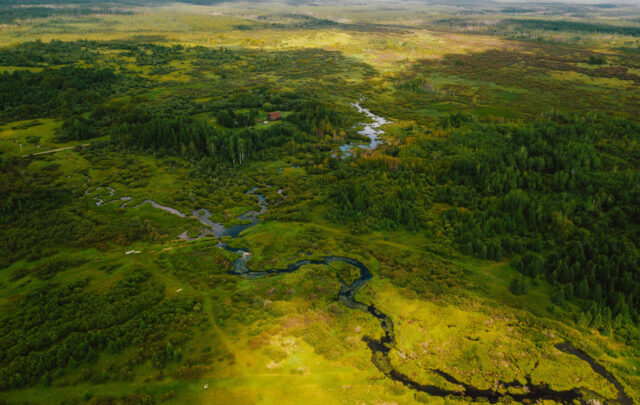
How connected to your local place do you feel? Do you know where the nearest flow of water is? —I don’t mean down the drain! If you live in a city you may not be aware that streams are still flowing under the pavements. If you stand in the right place and listen, you can even hear them. The geographical area that catches all the water for a stream or river is called a watershed. Each one of us lives in a watershed and in the future we are likely to need to rely on our local bio-regions (that’s another way of talking about a watershed) and communities much more for the resources we need, and for the social, cultural and community bonds needed to sustain our wellbeing.
 In Transition we focus quite a bit on peak oil, but peak water is also on the horizon. It is likely that the geo-political conflicts of the future will be as much about water as about oil. In most parts of the world local communities do not own their water supply. Like most of the “commons” – the resources of the natural world that sustain human life – water has been commodified and ownership is by companies and shareholders. To give an example close to home, in 2006 Thames Water Holdings plc was acquired by Kemble Water Ltd. Kemble is owned by a consortium of investors which consists largely of pension funds and other long-term institutional investors from Europe, Canada and Australia. Ownership is no longer located in the hands of the users of the water and the responsibility of Kemble lies with its shareholders, not people living in the Thames valley.
The barons who drew up the Magna Carta in 1215 and forced King John to sign it at Runnymede on the Thames might be surprised to hear that. Alongside Magna Carta they also forced him to sign up to the Charter of the Forest, which dealt with the economic wellbeing, if not survival, of the common man. It gave the people rights to foraging, fishing, collecting wood, gleaning, grazing pigs and much else besides, and stopped the crown from amassing ever more woodland, grazing land, river usage and river-banks. If you are as fascinated as I am by the whole idea of the commons, where it came from and how it might inform our thinking now, read The Magna Carta Manifesto by Peter Linebaugh (2008, University of California Press).

So how might local communities step forward as stewards of their watersheds, reclaiming care of the commons (if not ownership)? For Schools in Transition, which is a new programme starting this autumn with 8 pilot schools, we are developing ways for any school to map itself first into its territory and then into its social system. We are using the watershed as our territorial boundary because everyone is in a watershed, wherever you are in the world: it is one of the oldest human boundaries. People in a watershed are related through the flow of water both upstream and downstream and a bio-region describes life lived in relationship within that biotic system.
 Mapping is one of the tools bio-regionalists use in re-inhabiting place. To quote Doug Aberley (Boundaries of Home: Mapping for local empowerment. 1994. New Society Publishers) “Our actions bear most fruit when interrelated in an ecologically – and culturally – defined place …. Maps show a vision for the future more clearly than thousands of words.” Onto them you can plot community forests, indigenous fauna and flora, apple orchards, sawmills, sources of food, a hydro-electric plant above a restored salmon-run, local businesses, empty land for growing food, cycle paths: maps can develop strategies of resistance as indigenous peoples know well.
The most powerful way to map a watershed is with large-scale paper maps that can be drawn on and walked around so we are planning to print out really large-scale and large format maps for schools. We are also looking at the best digital mapping platform that could be shared between schools and their communities. On top of the watershed the school maps the social system that it sits in, looks for the relationships that will move that system towards sustainability (like organic food growers, bee-keepers, renewable energy generation and local businesses) and defines a project that it can take action on in the local community. It could be lobbying for a new cycle path or clearing a waterway of non-native invasive plant species. The idea is that this is learning outside the walls of the classroom through solving real-world problems.

We want watersheds to enter the national consciousness and for people to take responsibility for these bio-regions, which means protecting them from pollution, seeing them as living systems, managing the natural and human resources within them well, valuing them as their basins of relations and feeling bounded once more by the natural world. If you know of a school that would like to be a part of the pilot please contact me: isabelcarlisle “at” transitionnetwork.org
Images
Map of the River Thames near City airport made by Year 3 children at Gallions School in Newham, How a Watershed Works from Basins of Relations (Brock Dolman, The Water Institute, California), River Dart, Dart Valley Watershed map