We have been traveling throughout the Heart of Turtle Island for the last two weeks. Water is our guide. The living flows of rivers that form a tapestry and give rise to one of the largest watersheds on Earth — the vast Mississippi River basin. In the last few days, we visited the headwaters of the largest river in this system. We were in Montana and went to where the Missouri River is born from the living flows that come down from the Rocky Mountains to nourish the northern High Plains.
A few days before that, we were at Lake Itasca. It is a very special place in Minnesota where glacial movements created deposits of gravel and sand in the form of a moraine. Now the water pools into a series of lakes — one of which gives birth to the Mississippi River. These are sacred lands of the Ojibwe people. The river is not born from a single location. It arises gradually from many layers of geologic and ecological processes. A continent carved by ice ages. Rainfall that seeps into the porous land. Wetlands and forests that filter and pool the water. Gravitational flows that pull it into a current that eventually leaves the headwater catchment.
And a river is born.
What can we learn from the sacred headwaters of the world? How can they guide us in learning how to think like a living planet? What might this have to do with strategic planning and the operational work of weaving regenerative efforts across the world? These are the kinds of inquiries that I carry with me as we make our pilgrimage through the Mississippi Basin.
Insights into bioregional funding ecosystems
Those of you who are familiar with my work will know that I have been involved in the creation of bioregional funding ecosystems for several years now. We have designed and implemented different kinds of funding pools that are scale-linked — meaning there are explicit relationships from one scale to another. For example, local regenerative projects are linked to a holistic landscape through thematically defined portfolios. Territories are linked with each other within a larger bioregion. Learning sites are held in coherent relationships with regional networks. This is described in our Billion Dollar Proposal for Regenerating Earth and in a case study that looks at Legitimate Intermediaries and Nested Funding Pools.
The question I’d like to explore today is this: What can we learn from sacred headwaters as we design the flow funding ecosystems that will be necessary for regenerating entire bioregions? This is a question we have been exploring in practice since 2020, by mobilizing resources across scales and in different geographic settings. Now we are being guided in our thinking by the sacred headwaters as they shape how we see the world.
In my previous article, I shared an update from the road about our visits to different places where bioregional learning centers are taking form in the Ozarks, Missouri River Valley, along the shores of Lake Michigan, and in Madison, Wisconsin. You can read about it here. What I’d like to do today is share our travels to three major headwaters — with stops at several important river confluences — to see what we might learn from them as we envision how to Birth 1000 BLCs with our Dandelion Strategy for Regenerating the Earth.
Listening to three sacred headwaters

In the second week of our bioregional pilgrimage through the Heart of Turtle Island, we visited three major headwaters — where the Mississippi, Missouri, and Yellowstone Rivers are born. It was deeply moving to experience what is shared (and what is distinct) about each place. Let us look at each of them in turn.
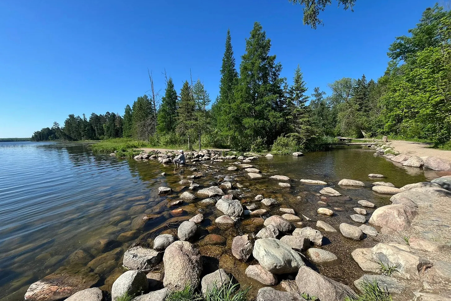
Lake Itasca: Birthplace of the mighty Mississippi

In the language of Ojibwe, the word Mississippi translates as “father of water” and it refers to a profoundly sacred landscape that is located near Lake Itasca in present-day Minnesota. This is a place that was shaped during the long Ice Ages through the movements of very large ice sheets that carved up the landscape and deposited a silt comprised of sand and gravel that geologists call a moraine.
As you can see in the photo above, there are many lakes embedded within gentle rolling hills. Each lake is a pool of water that seeps out of the silty hillsides — with one lake seeping into another until they arrive at Lake Itasca with enough force to generate a water current. This is how the Mississippi River emerges as it is pushed out of a spongy landscape filled with pristine pools of water.
We went to the visitors center of Lake Itasca State Park where I took photos of some of the information displays. Here is a map that beautifully reveals how the headwaters is geographically spread out across the entire Itasca Moraine. While many consider the “official” birthplace of the Mississippi River to be the point where it takes the form of a stream flowing out of the lake, it is more accurate to describe the entire headwaters system as what gives birth to one of the most important rivers in the world.
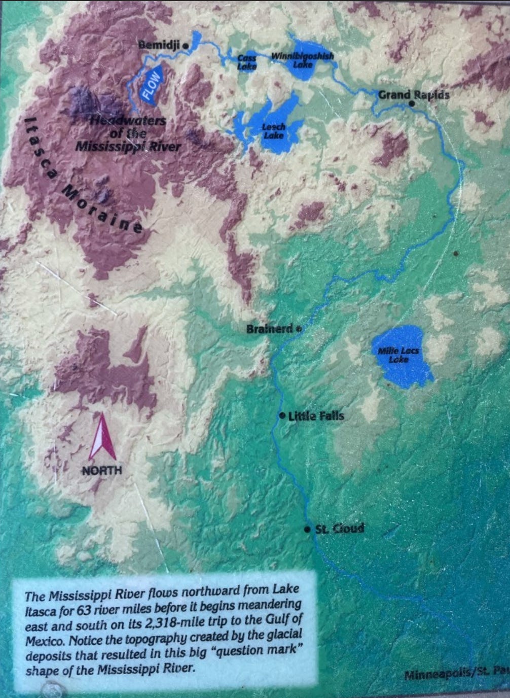
This distributed pattern of many processes that all come together at the right place — ancient ice sheets, silt deposits that created an elevated moraine, spongy land that pools water into several interdependent lakes, and a gentle pushing of the water that creates enough current to produce the initial stream of the river system. All of them come together as a meshwork of regenerative processes.
Where three rivers become one: The Missouri Headwaters

It is hard to imagine something more beautiful than the headwaters of the Missouri River — as three smaller rivers arrive to the same point in a ring of snow-peaked mountains of the Central Rockies to forge the largest river in North America. Again, there are sand and gravel deposits from the movement of ancient ice sheets.
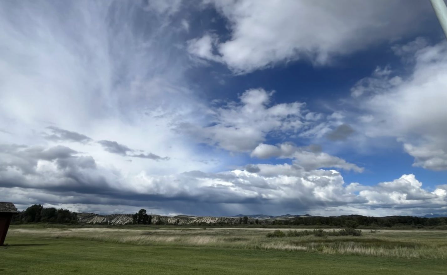
What makes this place different is that the landforms are tall mountain peaks that create a meteorological phenomenon called Orographic Lift, which refers to how air must rise over the mountain peaks in order to continue on its journey. This leads to the formation of rain clouds over the mountains with water that pools into the land to sustain the vast network of watersheds that all converge into the headwaters system.
You can see this in the photo I took below. Note how the skies are more clear as you move out in front of the mountains. Yet those who form above the peaks give rise to thunderstorms that drop a lot of rain along the edges of the mountain ring — all of which flow downward into the headwaters to form the Missouri River.
What this shows is that we have several key features of the headwater system that all come together and birth a great river. There are landforms conducive to gathering and pooling water. Gravel and sandy soil mean the water seeps into the ground everywhere the rain falls over the landscape. This continually feeds smaller streams that converge into one primary current of water that pushes out of the landscape as the way to birth a major river.
We were really struck by this combination of features that all come together in one place. It is the blending of regenerative processes that include geology, climate, and hydrology that make the headwaters occur.
Through a Super Volcano: Where the Yellowstone is born

Yellowstone National Park is world-renowned for its geothermal activity and the most densely populated basin of natural geysers on Earth. This is because it sits over a hot spot in the magma below Earth’s continental crust — a super volcano that (luckily for us) only erupts on hundred-thousand-year timescales.
The main channel of the Yellowstone River begins at the rocky face of Younts Peak. Many other small rivers and streams gather from the surrounding terrain and join with the Yellowstone River throughout the national park and farther downstream. You can see this in the watershed map below.
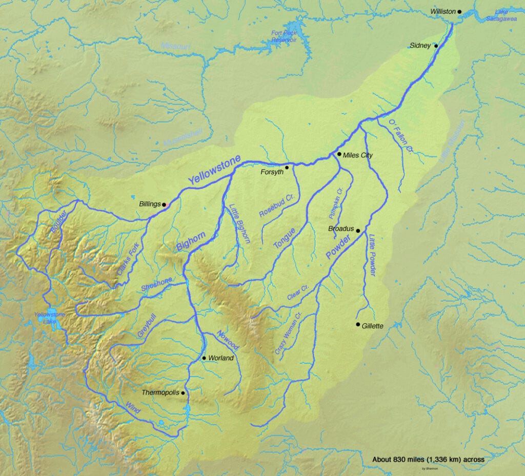
Again we see the distributed nature of the headwaters area. Landform features provide the container for waters to pool in many places and flow into each other. In this case, the primary water supply is snow pack in this vast region of the Central Rockies.
If you were asked to choose one place where the river system is born, it would be a misleading question. The reality is that many places are spread out across a larger geographic region that has the right combination of features to birth a major river system.
What can these headwaters teach us?

Let us begin with a note of caution. It is very easy to feel the desire for some kind of model that we can think with — which is prone to be abstracted into a framework by consultants and design strategists. We can learn a lot from these three sacred headwaters that will be of general insight for watersheds around the world. But when we attempt to bring our learnings into other realms, which we will begin to do in a moment with regenerative finance, I caution us that The Map is NOT the Territory!
Why do I say this? Because it is easy to be inspired by nature and then fall into the mental habit of translating what we learn into some kind of conceptual model. An example would be the Pando Grove (the world’s largest organism) inspiring some people to create a funding model for strategic impact. It is one experience to sit in board rooms and talk about abstract models, while a very different experience to journey into the remote landscape near Capitol Reef and visit the 47,000 identical trees in their real-world context.
I have a lot of experience with the pooling of financial capital through crowdfunding campaigns, Gitcoin rounds, targeted fundraising for portfolios of projects, and more. This includes working with trust-based philanthropy and flow funding practices. When I talk about what can be learned from sacred headwaters, it is because I see how poorly we enact what these real landscapes have to share. I don’t want people to sit in board rooms with fancy diagrams. I want them to visit the headwaters and seek their own spiritual relationships with them.
With this in mind, let us note a few of the key patterns:
- The water always arrives from somewhere else.
- It is transformed as it enters the headwater system by local geographic features.
- One of the key structures is that of a womb or some kind of vessel to gather and pool water.
- It gathers and pools from many places within the headwater system.
- The pooling itself is what gives rise to flow.
- Many small pools lead to many small flows.
- These flows converge and gather as they are pulled in the same direction by gravity.
- With sufficient convergence, the principal stream of the river takes form.
What I am describing here is the emergent behavior of a complex adaptive system. It is continually evolving and changing in details as energy moves through it. There are macro-scale patterns like the landforms and historic geologic processes. There are micro-scale patterns like small pools and localized contours within the large geography of the system.
It is fractal. You can see the same geometric patterns repeat across different scales. It is decentralized while having a tendency to gather and centralize the energy flows. And it is directional with cumulative forces aligning to achieve the emergent goal of birthing a major watershed system. And all of this continually nurtures and supports life to exist.
Now imagine what a financial system would do if it behaved like a headwaters system. There would be continual arrival of flows from elsewhere. The resources would be transformed by the shape and dynamic relationships of the system. Resources would pool into local places. Actions would converge in the same direction. And all of it would support the continual emergence and maintenance of life.
Pretty powerful, eh?
I have been talking about and experimenting with funding pools for a long time. They are described as nested tapestries of energy flows that support regenerative efforts on the ground. Now I will integrate what I am learning about the dynamics of headwaters to see how directional flow and accumulation of capacities can support larger shared goals.
For example, we have named our Dandelion Strategy for Regenerating the Earth. How we envision birthing at least 1000 bioregional learning centers by 2035. And how we seek to pool large amounts that continually flow into nested geographic systems with our Billion Dollar Proposal for Regenerating Earth. Now imagine that this planetary pool of money comes into headwater structures. That it nurtures small pools and convergent flows of regeneration that move up to the landscape and eventually continental scales.
Do you see what I am getting at? We can sit with nature. Visit her sacred places. Receive instructions about how to move energy. And flow our resources toward the regeneration of the Earth.
This is how sacred headwaters help show us the way.
Onward fellow humans.