A car-dependent society isn’t built overnight. It takes concerted effort by multiple levels of government and industry to make private cars the go-to, all-but-obligatory choice for everyday personal transportation.
If you want to see what car-dependency looks like on a map, you need to look at a regional or neighbourhood scale. You need to see the options people have for the kind of trips they make on a routine, everyday basis.
This series looks at the layout of car-dependency in my part of Ontario, Canada.
Durham Region is an administrative district on the east flank of Toronto. The Region covers about 2500 square kilometers, but most of the current population of about 700,000 lives in the southern communities bordering Lake Ontario.
As shown below, there is an extensive network of expressways and major arterial roads connecting Durham Region with itself and with the rest of the Toronto megalopolis. Two east-west expressways cross Durham Region, two north-south expressways cover part of the Region, and there are dozens other highways and major arterials.
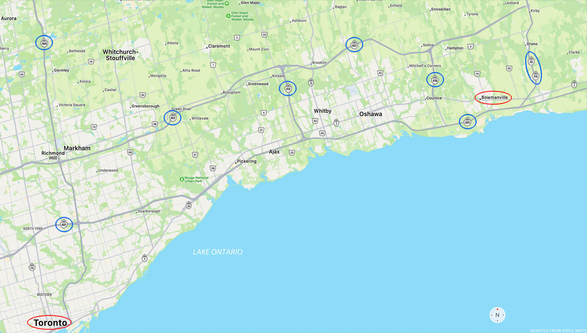
A region-scale map. The roads with signs circled in blue are multi-lane, controlled-access highways. Other roads shown in grey are major arterials. Downtown Bowmanville and downtown Toronto are about 75 kilometers apart.
The passenger-rail network, on the other hand, is terribly sparse.

Passenger rail routes through Durham Region, shown in thin blue lines.
One commuter rail line runs east from Union Station in downtown Toronto. It currently terminates in Oshawa, though an extension as far as Bowmanville is promised in a few years. (It’s been promised “in a few years” for more than a few years.) A long-distance line, Via Rail, passes through Bowmanville but does not stop. That means rail travel is not a realistic option for most Durham residents, most of the time, in most directions.
It wasn’t always this way. The passenger rail network was much more extensive a hundred years ago. Though I haven’t found a good map of regional rail lines in the 1920s, there is one from about 50 years earlier: 1875.
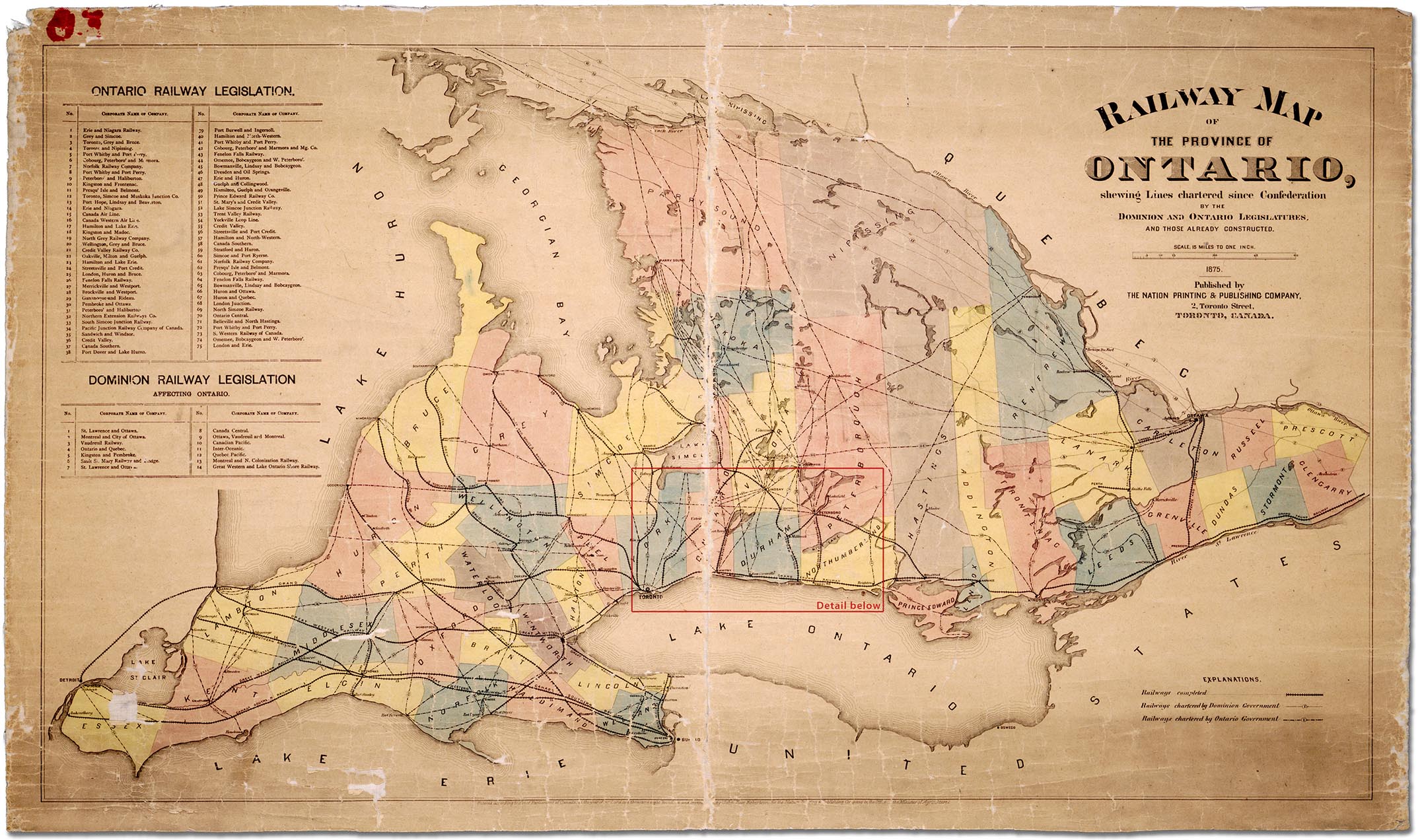
Ontario railways constructed or chartered in 1875. Image via Wikimedia Commons.
As shown below, in 1875 Durham Region residents already had not just an east-west connection to Toronto, but two passenger rail lines running north-south through the region. Other lines had been chartered and some were actually built and in operation by the early twentieth-century, though they are a faded historical memory today.

There are many reasons society might have chosen to fund extensive networks of highways, while letting rail networks wither and die. But two powerful industrial lobbies benefitted when passenger rail was eclipsed in favour of private cars. The consumption of liquid fossil fuels rose steeply with the ascent of car culture, to the benefit of Canada’s still large and still influential petroleum industry. And at the provincial level, “by the early 2000s Ontario had become the largest auto-producing jurisdiction in North America.”1
Widespread car-dependency is now taken for granted in Durham Region – except by the minority who are either unwilling or unable to get into a car every day. We can illustrate why with the aid of a few more maps.
Living right next to a city about the size of Chicago, in a metroplex of some 7.2 million people, many residents of Durham Region commute to work somewhere in Toronto or its suburbs. For most of these commuters public transit is an unattractive choice.
A major commuter rail line, the GO Train, does connect southern parts of Durham Region to downtown Toronto at Union Station. For those who work near Union Station or one of the other stations, the GO Train may be a great commuting option. For all others, public transit gets more complicated and less attractive.
Consider commuting to what is called “north Toronto” – an area now pretty much in the center of the megalopolis. This area is a typical commuting destination for Durham residents. As the map below shows, the trip is straightforward and relatively quick by car.
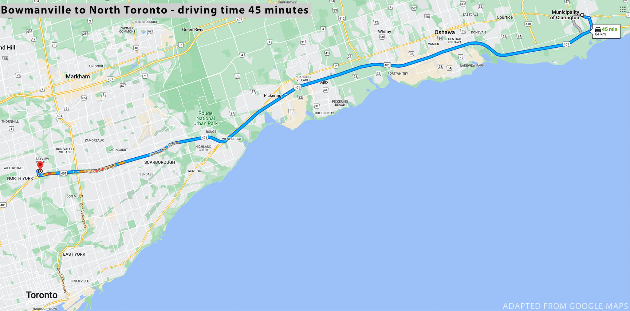
Driving from downtown Bowmanville to north-central Toronto, a distance of 64 km, takes about 45 minutes.
To make the same trip by public transit, you need to check schedules carefully and hope your connecting routes run at the hours you need them. Plus, you need to allow 2 to 2.5 hours for the trip that could be done by car in 45 minutes.
![]()
Taking public transit from downtown Bowmanville to north-central Toronto takes a minimum of 2 hours. Some of the routes run at reduced frequencies on weekends/holidays, and do not operate late at night.
Let’s look at another, shorter, trip. Ontario Tech University is the only university whose main campus is in Durham Region. Suppose you need to go from downtown Bowmanville to the Ontario Tech campus in Oshawa – just 22 or 23 kilometers. It’s easy by car:

But again, you need to budget more than twice as much time to go by transit:
![]()
For these and countless comparable inter-region trips, existing infrastructure and services put tremendous pressure on people who travel by transit. They might consider moving to a residence much closer to their destination – but housing costs are more astronomical the closer you go to Toronto. They might look for a different job or choose schooling closer to home – even if that means settling for a second or third choice. More likely, they might start saving for a car so they can become part of the traffic. And if none of these are possible, they need to devote a large chunk of each day to their commute.
Car-dependency takes more than one generation to build – but it’s not always easy to escape.
Stalled in the 1950s
A curious video advertisement was produced for General Motors in 1954. Most ads for car companies show their products cruising along scenic and empty highways. But “Give Yourself the Green Light” took a very different tack: it showed motorists sweating in stalled or crawling traffic, on roads packed with other equally frustrated motorists. In this case GM wasn’t selling cars, at least not directly – they were selling more roads. Specifically, the video was part of an intensive lobbying campaign to persuade voters and car consumers to support massive government expenditures for more and wider highways.2
That expanded highway construction effort still continues almost 70 years later. The roads have gobbled up vast tracts of land and vast sums of tax dollars, but haven’t vanquished the dreaded rush hour traffic tie-ups. Today, rush hours are much longer than an hour, and extend much farther out from city centers, through suburbs and exurbs.
But the current government of Ontario, led by Premier Doug Ford, remains under the spell of that 1950s vision of endless, wide, and free-flowing highways. True, they are now budgetting for and planning major, long-overdue subways and commuter rail expansions in the most crowded parts of the Greater Toronto Area. Perhaps they recognize there simply is no room for wider roads in those areas, and so the only way to reduce congestion is to give more drivers a way to leave their cars at home.
At the edges of urban sprawl it’s another story. Far out from the center of Toronto, where there are still no good public transit options, the Premier is pushing hard to build two more expressways along the north and north-west edges of the metro area. These highly controversial routes, if constructed, will augment ultra-expensive privately run toll road Highway 407, recently extended through Durham Region.
These expressways do more than eat up large amounts of space – which happens to be some of the best scarce farmland in Canada – for travel lanes, medians and interchanges. They also facilitate and encourage equally space-hungry housing forms and commercial developments – developments which will need abundant parking since driving will be the only to get to and from them.
In the next installment we’ll examine car-dependent development patterns at the neighbourhood level, along with the provincial and regional policies that continue to promote this pattern.
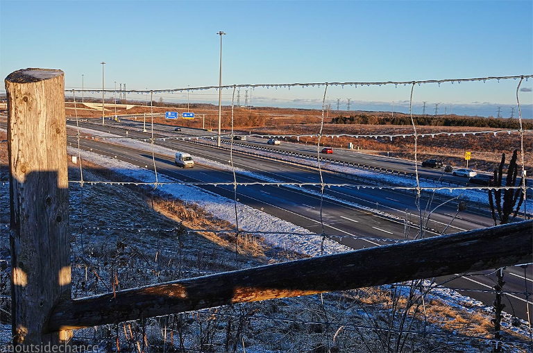
Photo at top of page: Restricted Access – Highway 407 toll route in northeast Durham Region, photographed on Feb 17, 2023. Full-screen image here.
Footnotes
1 The Canadian Encyclopedia, “Automotive Industry”.
2 The superb series Not Just Bikes includes many excerpts from the GM video along with commentary by vlogger Jason Slaughter, in the recent installment “Would You Fall For It?”


