How many people could recognize an ecological wound if they saw one?
Could we tell a natural arroyo from an eroding gully? Could we tell if plant pedestaling was a sign of proper land function or a sign of erosion? If we recognized a headcut in a wet meadow, would we be able to deduce why it was there or where it originated? Could we tell if a channel was aggrading or degrading or why we should care?
This issue hit home for me years ago when I heard Dan Dagget, an environmental activist, tell a story about a professor of environmental studies he knew who took a group of students for a walk one day in the woods near Flagstaff, Arizona. Stopping in a meadow, the professor pointed at the ground and asked the students, not so rhetorically, “Can anyone tell me if this land is healthy or not?” After a few moments of awkward silence, one student finally spoke up. “Tell us first if it’s grazed by cows or not,” he demanded.
The implication was clear: if cows grazed here, the land had to be unhealthy. If cows did not graze there, then things were “natural” and therefore fine. Dan’s point was that the actual condition of the land, visible as signs of health or ill-health, had become secondary to the political positions of the observers. The point that stuck with me over the years, however, was this one: we’ve become mostly land illiterate.
But reading the landscape is not as hard as it sounds. As an example, let’s take a walk together.
I’ll start at the back fence of our property near Santa Fe, but before I take a step I’m going to ask myself a question (as you might): Where do I live? I don’t mean my city, county, or state, but rather the geography or landform of my home ground. I live on 2.5 acres of gently sloping cold desert dominated by juniper and pinon trees, bunch grasses and annual weeds. The elevation is 7000 feet above sea level and the annual precipitation over the past one hundred years has averaged 12 to 14 inches. The landforms around our house include small hills and dry washes called arroyos.
If I wanted to, I could do some research to answer a few questions before starting my walk: What is the geology of the land where I live? What are the actual soil types? What plants and animals might have existed here before humans began to make their mark? What were the historical uses of this land before it became a 2000-home subdivision spread out over 13,000 acres? How have precipitation patterns changed in recent years, and if they have what effect has it had on the land?
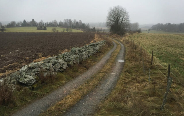
I know the soil here is easily eroded, and I’ve noticed that after a rain it caps in bare spots, meaning it forms a thin, hard crust. I know from experience that capping can be a problem if left undisturbed because crusts inhibit seeds from making it into the soil where they can germinate and grow. It also accelerates water runoff – and as I look around from our property line I can see bare spots on the land.
Now we begin to walk – and as we do, let’s pretend to be a raindrop for a moment. Everyone lives in a watershed – everyone – and thinking like a watershed is key to reading any landscape. All water that falls on the ground wants to go to the sea, thanks to gravity, so if you were a raindrop, how would you get there? In this case, our house sits at the tippy top of small drainage, called a greenbelt here, which means it’s easy to tell which direction the raindrop wants to flow: west.
Water coming off our grassless backyard (thanks to our chickens) gathers together not far from the bottom of our property into a tiny stream that picks up other tiny streams as it goes. A mile downstream it will merge with the Arroyo Pueblo, coming in from the north, which merges eventually with the Galisteo River, to the south, and then on to a final merge with the mighty Rio Grande near Santo Domingo Pueblo, thirty miles from my house. Technically, we’re part of the 460,000-acre Galisteo River watershed, but that’s too much for this raindrop to comprehend, so we’ll stick to our narrow greenbelt below my house.
Here’s a photo of capped soil near my house (a sign of poor land health):

The first thing I notice on our walk is that the footpath coming in from the right has captured most of the water flow in the greenbelt, causing it to become entrenched and as a consequence difficult to walk in! In many places, people have stepped out of the footpath as they walk, creating a parallel track, which has begun to erode as well.
On a steep section, I can see that water has spilled from the trail into the small channel, which is good, but I can also see grass pedestaling (grass plants that are confined to small pedestals of soil) and small rills in the soil on my right as I walk, which are signs of sheet erosion. I can see the sediment it creates deposited on the trail, where it is picked up by subsequent storms and carried downhill by rushing water, scouring the trail as it goes. I also know that storms in recent years have been much more intense than normal – and I can see the cumulative effects throughout the greenbelt.
This isn’t an idle issue. There are no live streams in our subdivision, which means the 16 million gallons of water our community consumes each month on average during the summer must be pumped from underground aquifers, some shallow and some deep. The deep ones are comprised of fossil water, meaning it’s been down there for a very long time, but the shallow aquifers are recharged by surface water, snow especially. The condition of the watershed directly influences the rates of recharge. If rain or snowmelt sinks into the soil, thanks to gentle gradients, decent vegetative cover, and uncapped soil, it boosts the recharge rate. If its shoots down eroded trails and washes off the land, however, the recharge rate drops significantly. In a high, cold desert that is enduring a low-grade but persistent drought, what’s happening in our micro-watersheds should be a concern to every resident.
My walk brings me to an intersection with another trail, where the greenbelt widens. Near the junction are two tree stumps, both rough-cut by an axe, which suggests they were chopped down decades ago. It serves as a reminder that this area has been in use for a long time, first by prehistoric Native Americans, then by Spanish colonists, starting four centuries years ago, and now by the houses that line both sides of the greenbelt, including the dogs, cats, and people that live in them.
I walk on.
Land Literacy Pop Quiz: which side of the fence below looks healthier? Next question: which side is grazed by cattle?

Answer to both: the left side. The right has been rested for 20+ years from livestock grazing. (location: central Texas)
I follow an old road that parallels the railroad track, then I turn right and head up a big arroyo on a footpath. As I keep going I begin to wonder if I’m walking in what used to be an old ranch road. It’s wide enough for a truck, but it’s sunk three to four feet below the old floodplain, suggesting that if it had been a road at one point it caught the water flow and eroded downwards. I knew this was a quick way to alter the natural hydrology of arid environments, thanks to our easily erodible soils.
I keep going. The trail bobs and weaves around trees, rising out of the wash for a while, then slipping back down. Eventually, the arroyo fans out and I begin to see more traces of old ranch roads. Fifty years ago, most of this country was one big ranch, and if you look carefully you can see traces of old irrigation ditches on the land. Unfortunately, I can also see two- and three-foot headcuts in the old roads, each of which suddenly appeared three summers ago as the result of intense rainstorms. When I began walking in this arroyo ten years ago, none of the roads had a headcut. That tells a story of troubling changes in the region – but not the first sign of trouble.
As I walk, I also notice that long stretches the arroyo’s bottom rest well below the old floodplain, though not in an old road, indicating there have been serious erosion problems here in the past, likely the consequence of overgrazing by unmanaged livestock. It’s another familiar story – too many cows, too little grass. The remedies are familiar as well. There are three large earthen dams in the greenbelt, each constructed, I’m certain, in an attempt by the ranch owner to impound floodwater and slow the erosion. They probably doubled as stock tanks, but standing on them I definitely get the sense that humans were struggling to keep the land from unraveling here – and to some degree they succeeded. The arroyo’s edges have laid back over the years and are now nicely vegetated, meaning they are no longer actively eroding. The dams didn’t breach, which suggests the floods were kept under control, and the old roads were still in decent shape – at least until very recently.
As I near my exit point from the arroyo, I wonder what other questions I should be asking about the land as I walk? How about the plants that I see? What do the different species, age-class distribution, and vigor of the plants tell me? Does the area look like it’s getting wetter or drier? Are there visible impacts caused by deer or other wildlife, besides the ubiquitous coyotes and rabbits? Has there been a fire recently? Any other natural disturbances? What other cultural impacts are there? What about the impacts of the modern roads? The mountain bike tracks I see? What about all the dog poop?!
I come to another headcut – a big one. What would we do if we wanted to repair it and restore the water and carbon cycles here? There are no wet meadows or riparian areas in this greenbelt that I know of (except behind the earth dams after a good rain), so carbon sequestration isn’t really an issue. The land could certainly grow more grass than it has, and thus store more carbon than it does currently, but that would be a tall order for a subdivision like ours. Most homeowners don’t venture into the greenbelts, from my experience, much less try to “read” them from a land-health perspective. The headcuts don’t threaten anyone’s home (not yet), so there’s no need to raise alarm bells. Still, reading the landscape on my walk tells me it could be in better shape – if we wanted to make it so.
Do we?
A few years ago, the homeowners association hired a herd of goats, plus two handlers, to chow down on the weeds in the greenbelts, with great effect. The goats were popular, and for a while I felt optimistic about getting our greenbelts into better shape. Then came the chicken wars. Last year, an ugly row over backyard hens erupted in our community, dividing neighbors and effectively putting an end to using livestock to improve the land’s health. It’s a sign both of ignorance and illiteracy, I’m afraid. Not only do we not know how to read a landscape very well, we’ve lost sense for the positive role animals can play on the land.
The dirt road gives way to pavement and I turn left at an intersection. It’s been a wonderful walk on a warm, late afternoon and as I look up into the sky I see the clouds beginning to assemble themselves into another evening performance. The pinks and grays and oranges and maroons of our sunrises and sunsets remind me almost daily that the world is full of color, light, sound, touch, and other positive energy. It’s an inspiring and hopeful time to be alive – if we choose to make it so. We can be rich. It also reminds me that we can’t be spending all our time looking at our feet. We need to be looking up, at the clouds, at a world that is infinitely beautiful.

Excerpted from Soil, Grass, Hope: a Journey Through Carbon Country http://www.amazon.com/Grass-Soil-Hope-Journey-Through/dp/1603585451